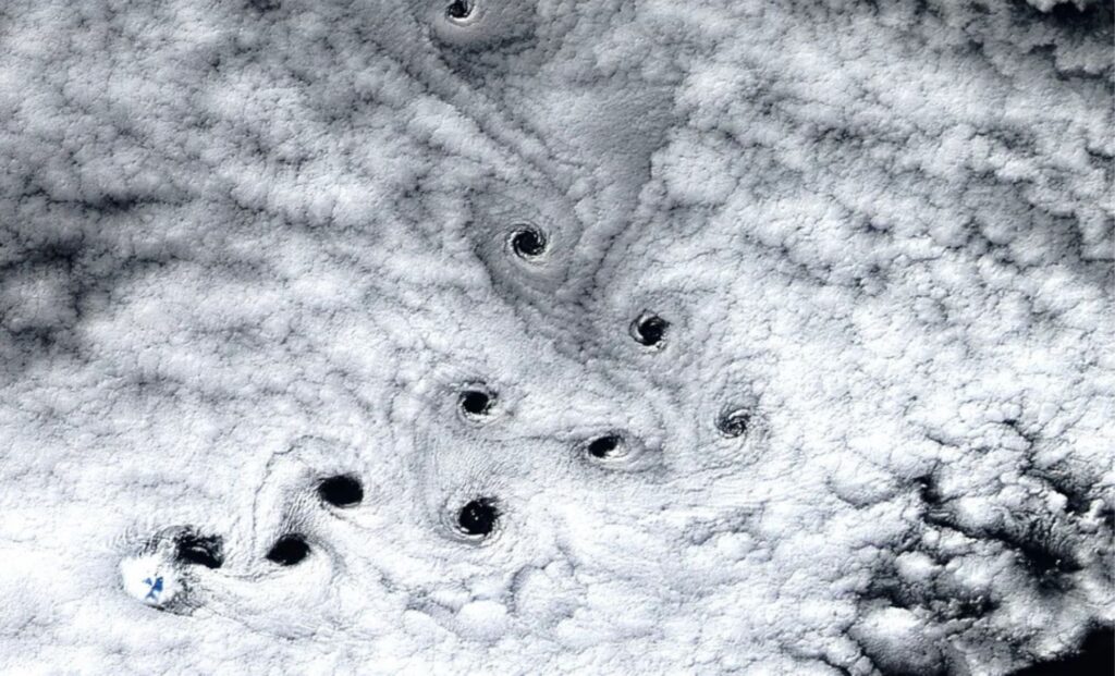
A satellite orbiting Earth captured something strange off the coast of Heard Island, a remote volcanic landmass located roughly 900 miles (1,448.41 km) north of Antarctica. The image, later released by NASA, showed a row of dark, swirling holes puncturing a vast sheet of white marine cloud. Each void was nearly 13 kilometers across, their spiraling pattern unmistakable. From space, it looked as if the sky had been pierced by a series of spinning drills.
What the satellite caught wasn’t a glitch or an atmospheric anomaly. It was a rare, almost perfectly choreographed dance of air and cloud — a sequence of von Kármán vortices, spirals formed when wind flows past a tall object and begins to twist downstream in alternating directions. These spirals are not new to science, but the way they appeared that day — unusually sharp, bending mid-stream, and starkly visible — left meteorologists and satellite analysts alike reaching for better explanations.
Heard Island, an uninhabited territory of Australia, is home to Mawson Peak, an active volcano that rises 2,745 meters above sea level. The peak is often shrouded in clouds, battered by wind, and sits in the path of the Furious Fifties, powerful westerlies that tear through the Southern Ocean. That volatile mix of high terrain and fast-moving air created the perfect setting for this spiral spectacle.

Most atmospheric vortices go unnoticed by the public, hidden in fine cloud streaks or occurring over unremarkable terrain. But in this case, the cloud layer was unusually dense, and the air currents strong enough to punch visible holes into it. Instead of producing wispy curls, the vortices carved out dark voids, leaving behind a visual signature that felt more like an artist’s brushstroke than a natural process.
When Wind Meets Mountain
Von Kármán vortices, named after Hungarian-American physicist Theodore von Kármán, are a well-documented phenomenon in both atmospheric science and fluid dynamics. They form when a steady stream of wind encounters an obstacle—like a mountain or island—and the airflow splits around it. As the two streams converge again on the other side, they produce a repeating pattern of rotating eddies.
In more common examples, such as those seen over the Canary Islands or Guadalupe Island, these patterns show up as faint spirals in light cloud cover. But what makes the Heard Island case so unusual is how visible and distorted the vortices became. According to NASA’s Earth Observatory, the vortex train was initially moving northeast, then abruptly shifted direction by nearly 90 degrees mid-flow.


The likely culprit? A burst of strong, sporadic winds from the west — part of the Furious Fifties — that overpowered the initial current. “It’s like throwing a stone into a river,” explains Harry Baker, a science journalist for Live Science, who covered the satellite image’s reemergence in 2025. “Only here, the river is the atmosphere, and the stone is a volcano.”
A Rare Sight, Not a Rare Process
Though the May 2016 image has recently resurfaced in media and scientific discussions, similar patterns have been observed in other parts of the world — just less dramatically. The Moderate Resolution Imaging Spectroradiometer (MODIS) on NASA’s Aqua satellite has captured von Kármán vortices over Greenland, St. Helena, and the Pacific Ocean, each time offering a glimpse into the invisible forces shaping our skies.
What differentiates the Heard Island event is the clarity of the vortices and their mid-stream deflection. Such sharply defined structures are uncommon and typically require a unique balance of cloud thickness, wind speed, and terrain elevation. Most peaks that generate strong vortex patterns are significantly taller than Mawson Peak, which makes this instance all the more surprising.
A technical note from the National Weather Service explains that even modest landmasses can disrupt wind flow dramatically, especially in regions where lower-level wind patterns shift suddenly with temperature or pressure changes. In this case, the vortex trail’s distinct arc may serve as evidence of real-time weather dynamics too subtle to detect from the ground — and too powerful to ignore from orbit.


Seeing the Atmosphere Through Its Own Fingerprints
In an era of near-constant Earth monitoring, it’s rare for a satellite image to spark genuine curiosity. But the 2016 capture of these spirals — and their quiet resurfacing nearly a decade later — underscores how much remains hidden in plain sight. While the von Kármán pattern is well-understood mathematically, its dramatic visibility here suggests an intersection of natural forces that’s rarely witnessed in full.


At the center of this story is a tiny volcanic island few people will ever visit, surrounded by some of the planet’s fiercest weather, and documented by some of its most advanced technology. It’s a reminder that fluid motion, despite being all around us, still has the power to surprise — and sometimes, to mesmerize.
The main study referenced in the image analysis was compiled by NASA’s LANCE/EOSDIS Rapid Response Team and published through the Earth Observatory, with image contributions from MODIS and Landsat 8.

