

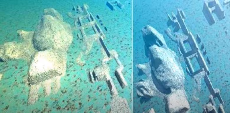
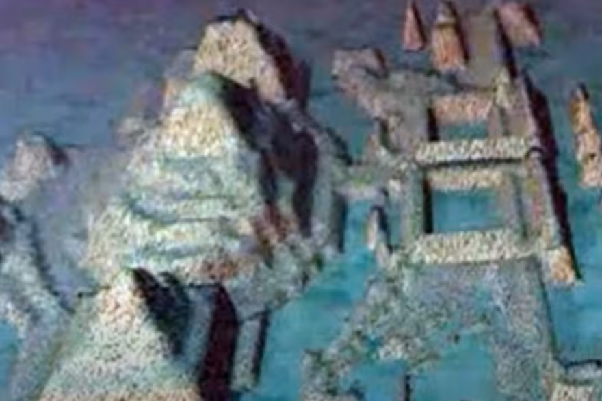
In the summer of 2001, a Canadian research team conducting routine sonar mapping off the western coast of Cuba spotted something unexpected. Beneath 2,000 feet of Caribbean water, their equipment returned images of symmetrical stone structures—linear formations, circular patterns, and pyramid-like shapes sprawled across the seafloor. To the untrained eye, they resembled an ancient city plan, the kind etched into textbooks or imagined in myths.
What followed was a flurry of speculation, headlines, and high hopes. Could these be the remains of a long-lost civilization, predating even Egypt’s pyramids? Or was it simply geology playing tricks again—an illusion conjured by time, tide, and tectonics?
More than two decades later, the site remains unexplored in any serious, peer-reviewed capacity. The original expedition led by Advanced Digital Communications (ADC), a Havana-based company working jointly with the Cuban government, collected initial footage and sonar data. But funding dried up. Institutional interest waned. And the site, located off the Guanahacabibes Peninsula, slipped back into the quiet of the deep.

Yet as old images resurface on social media and fringe theories re-emerge in digital documentaries, so does public interest. In a scientific landscape defined by data, the mystery off Cuba’s coast endures not for what we know—but precisely for what we don’t.
Sonar Echoes and a City-Shaped Illusion
The 2001 expedition used side-scan sonar, a common method for mapping the seafloor, typically employed to locate shipwrecks. What they found instead were formations stretching over several square kilometers, laid out in rectilinear grids. Initial footage from a remotely operated vehicle (ROV) revealed what looked like massive blocks with smooth surfaces and sharp edges—some rising in shapes reminiscent of step pyramids.
Paulina Zelitsky, a Russian-born engineer and co-founder of ADC, told BBC News at the time: “It’s a really wonderful structure which really looks like it could have been a large urban center.” But she also urged caution: “It would be totally irresponsible to say what it was before we have evidence.”
Despite public excitement, peer-reviewed archaeology journals have never published formal findings on the site. No academic institution has verified the sonar images or ROV footage. Without physical samples, there’s no material proof—just ghostly echoes on a monitor and the tantalizing possibility of misinterpretation.
Too Deep, Too Old?
One of the biggest challenges to the lost-city theory is depth. The structures lie roughly 650 meters (2,133 feet) below sea level. For a human-made settlement to be submerged at such depths, it would have to be at least 50,000 years old, according to Dr. Manuel Iturralde, former chief geologist at Cuba’s Natural History Museum. That predates any known civilization by tens of thousands of years.
“Sea level hasn’t risen enough in the last 6,000 years to submerge something that deep,” Iturralde told National Geographic in a 2002 interview. He reviewed the ADC data and called the formations “peculiar,” though he admitted geological explanations—like fractured limestone platforms or coral terraces—could not be ruled out.
Still, natural formations of such apparent symmetry are rare. And that ambiguity continues to invite both professional scrutiny and amateur fascination.
Why No One Has Returned
Despite the bold implications, no major scientific institution has returned to the site. The University of Southampton’s School of Ocean and Earth Science, one of the world’s top marine geology research centers, has never publicly addressed the Cuban discovery. Neither has NOAA nor UNESCO’s underwater heritage program.
In part, that may stem from the difficulty of deep-sea exploration. A return expedition would require advanced ROVs, geological sampling tools, and a multi-disciplinary team. Costs would likely run into the millions—an investment few are willing to make without clearer evidence.
And then there’s the political context. The discovery occurred in Cuban territorial waters during a period of tight U.S.–Cuba tensions. Collaborative research has always been complicated, even more so for a privately owned Canadian-Cuban venture operating under a media spotlight.
The Myth That Won’t Sink
While scientists tread carefully, the internet doesn’t. YouTube channels like Ancient Architects and independent coverage by ArkeoNews have revived the story, drawing links to Atlantis, pre-diluvian civilizations, and pseudoscientific timelines. The site has become part of a growing constellation of fringe narratives—where geology blurs with mythology and sonar maps become Rorschach tests.
Still, genuine experts remain intrigued. Zelitsky, now retired from deep-sea work, once described the structures as “too organized to be natural.” But without follow-up data, such claims hang in limbo.
In the end, the only certainty may be the ocean’s ability to hide its past. Whether the Cuban anomaly is a case of misread geology or a sunken chapter of prehistory, the mystery underscores a simple truth: more than 80% of the ocean remains unmapped and unexplored.